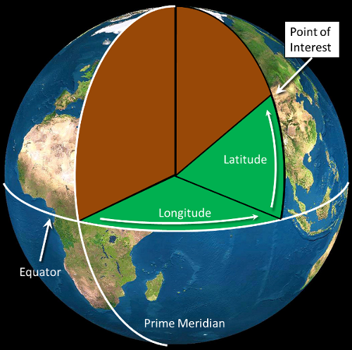
When we describe the Earth in spherical coordinates it is called Geographic, or Un-projected. The most common system for locating points on the earth is with "Longitudes" and "Latitudes". Both longitude and latitude are angles measured with the center of the earth as an origin. A longitude is an angle from the prime merdian, measured to the east (longitudes to the west are negative). Latitudes measure an angle up from the equator (latitudes to the south are negative).

Figure 1. With an angle of longitude and an angle of latitude, we can locate any point on the surface of the earth.
You've seen lines running across maps your whole life and may not have noticed them. The lines running North to South are called "Meridians" or "lines of longitude" (Figure 2), while the lines running East to West are called "Parallels" or "lines of latitude" (Figure 3).


Note that the lines are parallel when we look at the earth from the equator. If we look at them from the poles, they appear circular.
 |
Latitude: The angle between the equator and any point, measured from the center of the Earth. |
 |
Longitude: The angle between the prime meridian and any point. |
The system we will work with the most encodes longitude from -180° in the middle of the Pacific to 0° at the Prime Meridian, which runs through Greenwich, England and back to 180° in the middle of the Pacific.

Another common and older way of encoding longitude is from 180° West to 180° East.
A rare encoding is to go from 0° at the Prime Meridian through 360°.
The system we will work with most encodes latitude from 90° to -90°.

Another common way of encoding latitude is from 90° N to 90° S.

© Copyright 2018 HSU - All rights reserved.